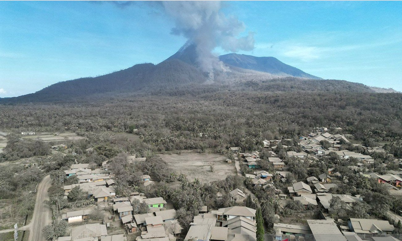
Mount Lewotobi Laki-laki, located in East Flores, East Nusa Tenggara, erupted five times on the evening of Monday, May 19, 2025, between 6:00 p.m. and midnight (Central Indonesia Time). The eruptions produced glowing lava visibly emerging from the crater.
According to Herman Yosep S. Mboro, an officer at the Mount Lewotobi Laki-laki Volcano Observation Post, the eruptions generated ash columns rising between 500 and 4,000 meters with grey-colored smoke. Seismic activity recorded amplitudes between 44 and 47.3 millimeters, lasting from 43 to 180 seconds.
Potential Volcanic Mudflows
Standing at 1,584 meters above sea level, the volcano discharged lava flows in two directions: northeastward for 4,340 meters and west-northwestward for 3,800 meters from the eruption center. Loud rumbling sounds were heard from the observation post in Pululera Village, Wulanggitang District. The volcano is currently at Alert Level IV (Warning).
Authorities have urged residents and visitors to avoid any activity within a 6-kilometer radius of the crater and within a 7-kilometer sectoral radius to the west, north, and northeast. People are advised to remain calm, follow official guidance, and avoid spreading or believing unverified information.
Residents near the volcano should also remain alert for potential volcanic mudflows, particularly during heavy rainfall. Rivers originating from the mountain could carry volcanic debris into nearby areas, including Dulipali, Padang Pasir, Nobo, Nurabelen, Klatanlo, Hokeng Jaya, Boru, and Nawakote. Those affected by volcanic ash are advised to wear masks or cover their nose and mouth to avoid respiratory issues.
Local governments are encouraged to maintain close coordination with the Mount Lewotobi Volcano Observatory in Pululera Village and the Center for Volcanology and Geological Hazard Mitigation (PVMBG) in Bandung for optimal disaster response.
The volcano’s status was raised to Level IV (Warning) on the evening of Sunday, May 18, 2025, at 8:00 p.m., based on increased seismic activity and visual observations. Head of the Geological Agency, Muhammad Wafid, confirmed that the elevated volcanic activity warranted the change from Level III (Alert) to Level IV.
Aviation Disruptions Due to Volcanic Ash
According to Kompas.com, The eruption has had significant impacts on air travel. Management at I Gusti Ngurah Rai International Airport in Bali confirmed the cancellation of seven international flights due to volcanic ash from Mount Lewotobi.
According to General Manager Ahmad Syaugi Shahab, most affected flights were operated by Australia-based Jetstar Airways, with routes to and from Melbourne, Sydney, Brisbane, Adelaide, and Perth. Additionally, one AirAsia flight from Kuala Lumpur was also canceled.
Cancellations occurred between 8:45 a.m. and approximately 3:00 p.m. (Central Indonesia Time). While no domestic flights have been canceled so far, volcanic ash did cause delays to flights heading to Labuan Bajo, including services operated by AirAsia.
Five more international flights experienced delays, including routes from Singapore (Singapore Airlines), Bangkok (Thai AirAsia), Kuala Lumpur (AirAsia), and Brisbane and Melbourne (Virgin Airways).
Continued Volcanic Activity and Hazards
Volcanic activity has intensified since March 20, 2025, with 117 volcanic earthquakes recorded by 6:00 p.m. that day. During the observation period from March 13 to 20, officials recorded 55 eruption quakes, 176 emission quakes, 67 harmonic tremors, and other types of seismic activity. Ash columns during this period reached heights of 1,000 to 2,500 meters.
According to Wafid, there is a potential for directed blasts—explosive eruptions aimed in specific directions—toward the northwest, northeast, and southwest slopes of the volcano. Volcanic material deposited around the mountain also poses a risk of turning into mudflows during heavy rain.
On March 19, continuous microtremors with a dominant amplitude of 3.7 mm were detected, indicating upward magma migration and the potential for stronger eruptions.
Public Advisory
In light of the Alert Level IV status, the Geological Agency recommends that residents and tourists avoid all activity within a 7-kilometer radius and up to 8 kilometers in the southwest and northeast sectors of the eruption center.
According to Detik.com, People affected by volcanic ash should use masks or other respiratory protection to prevent health problems. In addition, those living near river basins that originate from Mount Lewotobi should be alert to the risk of lahars, especially in areas such as Dulipali, Padang Pasir, Nobo, Kilatanlo, Hokeng Jaya, Boru, and Nawakote.
Sources: Kompas.com, Detik.com
Feat Image: AntaraNews//Aditya Pradana Putra